Benton County Planning Division
Flood Management Program

County Roles and Responsibilities:
-
The Planning Division is responsible for administering the
National Flood Insurance Program
(NFIP) for the County, which requires that all development in the Federal Emergency Management Agency (FEMA) designated areas of special flood
hazard (SFHA) comply with Federal mandates as well as the Benton County's
Floodplain Regulations.
As part of the County’s duties to administer the NFIP Program, the Planning Division oversees sound floodplain management practices, including;
- Working with local property owners, realtors, contractors, surveyors, engineers, and developers in addressing flood issues / problems.
- Require that all development within the FEMA Special Flood Hazard Area (SFHA) submit a Floodplain Development Permit (FDP) application and be approved prior to any land disturbance.
- Assisting with identification of flood risk / hazards as noted on the FEMA Flood Insurance Rate Maps (FIRM's).
- Assisting with identification of flood risk / hazards that may not be noted on the FEMA FIRM's.
- Maintaining and managing the County's Flood Insurance Rate Map FIRM repository.
- Assisting with research on historical flood risk identification, accessing archival FEMA FIRM's.
- Ensuring that all FEMA approved Letters of Map Correction (LOMC's) are properly maintained.
- Ensure continued compliance with FEMA’s Community Rating System (CRS).
Flood Protection Information:
- Specific property protection measures that may be taken before, during, and after a flood event to either eliminate and or reduce the risk of flood damage to property.
- Click HERE to access the 'Benton County Flood Protection Brochure', which has more details on flood protection measures, such as elevating a structure, constructing barriers, 'dry floodproofing', and 'wet floodproofing'.
- Flood safety Information such as sources for warnings, precautions to take before, during, and after a flood event.
- Real time stream gauge information from Federal and local sources.
- FEMA Flood Protection Information Materials:
- NFIP Flood Preparation and Safety
- Protecting Your Home and Property From Flood Damage
- Above the Flood: Elevating Your Floodprone House
- Elevated Residential Structures
- Protecting Manufactured Homes from Floods and Other Hazards
- Protecting Building Utilities From Flood Damage
- Click HERE to access the 'NFIP Flood Preparation and Safety' public awareness brochure.
- Click HERE to access the FEMA 'Protecting Your Home and Property From Flood Damage' booklet.
Flood Services Offered by the Planning Division:
- Whether a property is in or out of the Special Flood Hazard Area (SFHA) as shown on the current Flood Insurance Rate Map (FIRM) of Benton County.
- SFHA boundaries in relation to properties of interest can be seen by utilizing the Benton County interactive GIS 'Basemap'.
- Click HERE to access the Benton County 'Basemap' viewer.
- Click HERE to access FEMA’s Map Service Center to create your own digital FIRM.
- Hard copy FIRM’s are also available for at the planning division or Bentonville Public Library.
- Assistance with specific identification of flood risk, such as where the SFHA area is, any Base Flood Elevation (BFE) data, and how these boundaries relate to detailed site topography.
- Updates to the FIRM's are made when official documentation from FEMA is received.
- Handouts on the flood insurance purchase requirement that can help people who need a mortgage or loan for a property in the SFHA.
- Official, signed copies of the most current Elevation Certificates (EC's) for new and substantially improved structures in the SFHA.
- Flood related problems not shown on the FIRM, special flood related hazards (dams or levees), historical flood information, and natural floodplain functionality.
- Detailed points of contact for local architects, engineers, or contractors.
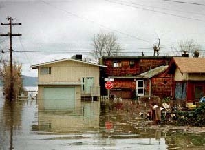
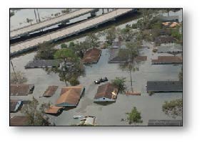
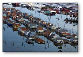
Flood Hazards in Benton County:
- Due to the location of the City of Rogers, on a ridge line, streams that carry drainage through the city fall rapidly to the east and southwest. The rapid fall of these streams creates high velocity runoff that results in fairly rapid flooding for short periods of time.
- Flooding in all areas can come with little warning. Even though they appear to move slowly (three feet per second), a flood two feet deep can knock a person off their feet or lift a car.
- Your property may be high enough that it was not flooded recently. However, it can still be flooded in the future because the next flood could be worse. If you are in the floodplain, the odds are that someday your property will be damaged.
- Sager Creek is the principal source of flooding in the City of Siloam Springs. Although a major portion of the populated areas is on high ground, damaging floods have occurred along Sager Creek since 1892. The June 8, 1974 flood was the most severe since 1892. Downtown businesses on Main Street were flooded to a depth of seven feet and three lives were lost.
- McKissic Creek is another major flooding source in Benton County. With the rapid growth and development in the Bella Vista / Bentonville area it is imperative to keep McKissic Creek flowing to its full capacity.
- Property along the Illinois River in the far southwestern reaches of the County have been subjected to several '100-year' flooding events (2007, 2011, and 2015 most recently).
Flood Insurance Information:
- If you don’t have flood insurance, talk to your insurance agent. Homeowner's insurance policies do not cover damage from floods. However, because Benton County participates in the National Flood Insurance Program, you can purchase a separate flood insurance policy. This insurance is backed by the Federal government and is available to everyone, even for properties that have been flooded.
- Some people have purchased flood insurance because it was required by the bank when they got a mortgage or home improvement loan. Usually these policies just cover the building’s structure and not the contents. During the kind of flooding that happens in Benton County, there is usually more damage to the furniture and contents than there is to the structure.
-
There are already a number of flood insurance policies filed in Benton County. If you are covered, check out the amount and make sure you have contents coverage.
Remember: Even if the last flood missed you or you have done some floodproofing, the next flood could be worse. Flood insurance covers all surface floods. - If your flooding problem is caused or aggravated by sewer backup, check out a sewer backup rider to your homeowners' insurance policy.
- There is a 30-day waiting period before National Flood Insurance Program coverage takes effect. Contact your insurance agent for more information on rates and coverage.
- Click HERE to search the NFIP's list of localized flood insurance agents.
- National Flood Insurance Program (NFIP) Insurance Information Materials:
- 'Know Your Risk'
- 'Nothing Can Dampen the Joy of Home Ownership'
- 'How the NFIP Works'
- 'Answers to Questions About the NFIP'
- 'Myths and Facts about the NFIP'
- 'NFIP – Summary of Coverage'
- 'Why You Need Flood Insurance'
- 'Top Ten Facts for Consumers'
- 'Your Homeowners Insurance Does Not Cover Floods'
- 'The Choice Is Yours – Write Your Own Insurance Policy Program'
- 'The Benefits of Flood Insurance Versus Disaster Assistance'
- 'Preferred Risk Policy – Low Cost Flood Insurance Information for Homeowners and Renters'
- 'Preferred Risk Policy – Low Cost Flood Insurance for Businesses'
- 'Flood Insurance Requirements for Recipients of Federal Disaster Assistance'
- 'Flood Insurance Claims Handbook'
- 'If Your Home or Business Has Been Flooded – Build Back Safer and Stronger'
- 'Increased Cost of Compliance Coverage – How You Can Benefit'
- 'Increased Cost of Compliance Coverage – Creating a Safer Future'
Property Protection Measures:
-
Floodproofing – The measures below are called 'floodproofing' or 'retrofitting'.
More information is available at the Bentonville Public Library, or by clicking HERE to access FEMA's 'Homeowners Guild to Retrofitting - Six Ways to Protect Your Home'. - Keep the water away by re-grading your lot, or, constructing a small floodwall or earthen berm. These methods work if your lot is large enough, if flooding is not too deep, and if your property is not in the floodway. The Benton County Planning Division can provide this information.
- Make structural walls waterproof and place watertight closures over the doorways. This method is not recommended for houses with basements or if water will get over two feet deep.
- Raise the house above flood levels. A small wood frame house can be elevated for less than $10,000.
- Many houses, even those not in the SFHA / floodplain, have sewers that back up into the basement during heavy rains. A plug or standpipe can stop this if the water does not get more than one or two feet deep. Plugs or standpipes can be purchased at a hardware store for under $25. For deeper sewer backup flooding, talk to a plumber about overhead sewers or a backup valve.
- If you know a flood is coming, you should shut off the gas and electricity and move valuable contents upstairs. It is unlikely that you will get much warning, so a detailed checklist prepared in advance would help ensure that you don’t forget anything.
- IMPORTANT NOTE: Wind driven rain entering your home through wind-damaged windows or doors is NOT covered by flood insurance. The NFIP considers the resulting puddles or standing water and resulting damage to be windstorm related, not flood-related.
- IMPORTANT NOTE: Any alteration to your building or land requires a Floodplain Development Permit (FDP) application and approval from the Benton County Planning Division. Even re-grading or filling in the floodplain requires a permit.
Reducing Flooding Risk:
- Do NOT dump or throw anything into the ditches or streams. Dumping in our ditches and streams in a violation of the Benton County Flood Prevention Ordinance. Even grass clippings and branches can accumulate and plug drainage channels. A plugged or clogged channel cannot carry water away, resulting in flooding to property in places that it otherwise would not. Remember, every piece of trash or debris contributes to flooding.
- If your property is next to a ditch or stream, please do your part and keep the banks clear of brush and debris. The County has a stream maintenance program which can help remove major blockages such as downed trees.
- If you see dumping or debris in ditches or streams, contact the Benton County Environmental Services Division at (479) 271-1083, or, the Benton County Road Department at (479) 271-1052.
- Click HERE to access the FEMA booklet 'Protecting Floodplain Resources – A Guidebook for Communities'
- Click HERE to access the FEMA booklet 'Reducing Damage from Localized Flooding – A Guide for Communities'
Floodplain Regulations:
Click HERE to access the current County Floodplain Regulations
Click HERE to access all County Floodplain Ordinances (1988 – present)
Click HERE to access all County Floodplain Ordinances (1988 – present)
- The purpose of the County Floodplain Regulations is to promote the public health, safety, and general welfare and to minimize public and private losses due to flood conditions in specific areas by provisions designed to:
- Protect human life and health;
- Minimize the expenditure of public money for costly flood control projects;
- Minimize the need for rescue and relief efforts associated with flooding and generally undertaken at the expense of the general public;
- Minimize prolonged business interruptions;
- Minimize damage to public facilities and utilities such as water and gas mains, electric, telephone and sewer lines, streets and bridges located in floodplains;
- Help maintain a stable tax base by providing for the sound use and development of flood prone areas in such a manner as to minimize future flood blight areas;
- Ensure that potential buyers are notified that property is in a flood area.
- "No structure or land shall be located, altered or have its use changed [located within the SFHA] without full compliance with the terms of the Floodplain Ordinance and other applicable regulations."
- "A Floodplain Development Permit [FDP] is required for all structural development, placement of manufactured structures, clearing, grading, mining, drilling, dredging, placement of fill, excavating, watercourse alteration, drainage improvements, roadway or bridge construction, individual water or sewer installations or any other development in a Special Flood Hazard Area to ensure conformance with the provisions of this Ordinance. The permitted site shall be posted with a notice, provided by the floodplain administrator, evidencing the issuance of a development permit. Said notice shall be visible from a point of vehicular access to the property, and remain posted until the development is completed."
- New construction and/or substantial improvements for residential structures, must have the lowest floor, including basement, elevated 1 foot or more above the base flood elevation (BFE).
- The above standard for residential structures holds true for non-residential structures as well, OR, together with all utilities and sanitary facilities, may be made watertight and resist hydrodynamic loads and effects of buoyancy at the base flood level of the structure.
- For structures with fully enclosed areas (enclosures such as garages and crawl spaces) below the lowest floor, that are usable solely for parking of vehicles, building access or storage in an area other than a basement, and, which are below the base flood elevation and subject to flooding, shall be designed to automatically equalize hydrostatic flood forces on exterior walls by allowing for the entry and exit of floodwaters. Designs for meeting this requirement must either be certified by a registered professional engineer or architect or meet or exceed the following minimum criteria:
- A minimum of two openings having a total net area of not less than one (1) square inch every square foot of enclosed area subject to flooding shall be provided.
- The bottoms of all openings shall be no higher than one (1) foot above grade.
- Openings may be equipped with screens, louvers, valves or other coverings or devices, provided that they permit the automatic entry and exit of floodwaters.
-
Manufactured homes placed within zone A on a county's FIRM shall be installed using methods and practices which minimize
flood damage. For the purposes of this subsection, manufactured homes must be elevated one foot or more above the base flood elevation and anchored
to resist flotation, collapse, or lateral movement. Methods of anchoring may include but are not limited to use of over-the-top or frame ties to
ground anchors. This is in addition to all applicable state and local anchoring requirements for resisting wind forces. Screw augers or expanding
anchors will not satisfy the requirement of this provision.
Manufactured homes that are placed or substantially improved within zones AH and AE on the county's FIRM on sites:- Outside of a manufactured home park or subdivision
- In a new manufactured home park or subdivision
- In an expansion to an existing manufactured home park or subdivision, or
- In an existing manufactured home park or subdivision on which a manufactured home has incurred substantial damage as a result of a flood shall be elevated on a permanent foundation such that the lowest floor of the manufactured home is elevated to or above an elevation one foot above the base flood elevation and shall be securely anchored to an adequately anchored foundation system to resist flotation, collapse and lateral movement.
Manufactured homes placed or substantially improved on sites in an existing manufactured home park or subdivision within zones AH and AE on the county's FIRM that are not subject to this subsection shall be elevated so that either:- The lowest floor of the manufactured home is at or above an elevation one foot above the base flood elevation; or
- The manufactured home chassis is supported by reinforced piers or other foundation elements of at least equivalent strength that are no less than 36 inches in height above grade and securely anchored to an adequately anchored foundation system to resist floatation, collapse, and lateral movement.
-
Recreational vehicles placed on sites within zones AE on the county's FIRM shall either:
- Be on the site for fewer than 180 consecutive days
- Be fully licensed and ready for highway use, or
- Meet the permit requirements of section 10.3 (B) and the elevation and anchoring requirements for manufactured homes in Section 11.4 (C). A recreational vehicle is ready for highway use if it is on its wheels or jacking system, is attached to the site only by quick disconnect type utilities and security devices and has no permanently attached additions. In Zone A, the applicant or the applicant’s agent must determine a base flood elevation prior to construction. The BFE will be based on a source or method approved by the local floodplain administrator.
Floodplain Development Permit (FDP):
Benton County requires that all development, other than those specified as ‘exempt’ under current County regulations, be issued a Floodplain
Development Permit (FDP) prior to disturbing any land within the FEMA Special Flood Hazard Area (SFHA).
Floodplain Development Permit (FDP) applications must be competed under the direction from Planning Division Staff prior to applying for any permits for construction from the County Building Safety Division.
As part of the Benton County FDP Review & Construction Approval Process, the Floodplain Administrator may require the following supplemental documents in addition to the standard FDP application;
If you do see building or filling in a suspected floodplain without a County permit sign posted, please contact the Benton County Planning Division at (479) 464-6166.
Floodplain Development Permit (FDP) applications must be competed under the direction from Planning Division Staff prior to applying for any permits for construction from the County Building Safety Division.
As part of the Benton County FDP Review & Construction Approval Process, the Floodplain Administrator may require the following supplemental documents in addition to the standard FDP application;
- FEMA NFIP Elevation Certificate (2019 EDITION)
- Floodproofing Certificate (for Non-Residential structures)
- No Rise Certificate
If you do see building or filling in a suspected floodplain without a County permit sign posted, please contact the Benton County Planning Division at (479) 464-6166.